
Hiking in the Lower Blue Mountains
- John Bek
- Aug 21, 2021
- 5 min read

Updated: Sep 25, 2021

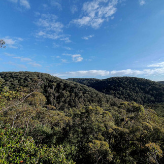
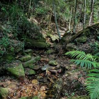
In this post we'll be featuring a bunch of walks we've personally done in the Lower Mountains, an area which spans from Lapstone to Faulconbridge. The Lower Mountains area is all about dense bushland, rugged gorges, rocky creeks and waterholes and temperate dells.
This list will grow as we continue to get out and explore.
There are hundreds of great trails located in our area, making it a true paradise for passionate hikers as well as for casual bushwalkers Not only is the scenery breathtaking but there's so much diversity in the trails. From temperate rainforests and lush dells to groves of scribbly gums, wind-sculpted rock formations, jaw-dropping cliffs, gorges and cascading waterfalls.
The Blue Mountains has rough terrain. However, there's some gradual ongoing reconstruction and trail management to help facilitate pleasant walks and hikes. There will be ups and downs, and that's to be expected given the geography of the region.
It's difficult to choose which trails are the best as every hike is unique in its geography, flora and scenery. Your fitness levels don't need to be super-high with any of them, providing you take your time and don't exert yourself. Having said that, a little fitness and stamina wouldn't go astray.
Being out in the Aussie bush without a map isn't wise, especially in the Blue Mountains. People getting lost happens way too often. When it comes to maps, we use a couple of nifty phone apps. Maps.me is our default go-to. It's free, it's very accurate (much more than Google), it's user-friendly and it doesn't use data. Another good one, which uses the same OpenStreetMap interface as maps.me, is AllTrails. Download them!
1. Martin's Lookout, Victory & Mahdala Gully Track - Springwood
Distance: 6 km loop Difficulty: Moderate Time Suggested: 2.5 to 3 hrs
Starting From: Batman Park, Springwood

This Lower Mountains loop is all about enjoying the beautiful lush forest, numerous rock ledges and caves and spotting a lyrebird, or two.
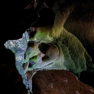
Park your car opposite Batman Park and make your way to Martin's Lookout via Martin's Lookout Trail. Take in the lofty view from the lookout and see exactly where you'll be walking in the valley below. The descent from the lookout has you stepping over rocks and down steps through rugged bushland to the serenity of Glenbrook Creek. Many waterholes can be found along the creek, all of which would be ideal for a cooling dip in the warmer months.
After walking parallel to the creek for just over 1 km, take a right and follow Magdala Creek on a gradual ascent through more temperate forest, past Martin's Falls, Magdala Falls and some imposing rock ledges before ending back up at Batman Park.


2. Faulconbridge Sawmill Historic Site - Faulconbridge
Distance: 4.3 km return Difficulty: Moderate Time Suggested: 1.5 - 2 hrs
Starting From: Highland Road, Faulconbridge

For those with a penchant for history, this walk is a great contender. The trail follows a ridge on the north side of Faulconbridge, descending a few times down a washed-out rocky path. It isn't long before the bush scrub turns into slightly overgrown temperate forest greened-up with ferns and tall trees.
The section at the bottom where you meet Linden Creek is strewn with debris from previous downpour run-off, but if you follow the rock overhang to your right you'll come to where the creek intersects with another one. Cross Linden Creek, then the one past it and follow the creek bed west. Before you know it you'll see a pair of carriage wheels in the creekbed and some steel cable. Continue along the right side of the creek and you come across the grand old boiler and a bunch of remnants dotting the area.
Back in 1913-1914, a steam-driven timber mill was built in the Linden Creek Valley with a 900 m-long tramway incline track back up the ridge. There were grand plans to log the area for its towering trees. There were four ownership changes over the short 14-year life of the mill, and any high hopes of a 'big industrial project' using exotic high-quality timbers for furniture-making simply didn't eventuate.


3. Turtle Falls - Faulconbridge
Distance: 7.9 km return Difficulty: Moderate Time Suggested: 1.5 - 2 hrs
Starting From: Adeline Street, Faulconbridge

The bulk of this walk is very easy due to the relatively flat terrain and part of it being a fire trail. The first branch to the left takes you right to the ridge line and has you traversing rocky platforms with glimpses across the shallow valley to Lawson.
Take the next short detour to the top of some large boulders with a narrow gap between them. It may not appear like much from the top, but if you make your way though the gap you'll understand why we'll nicknamed this rock as "The Grandstand".
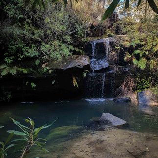
Back on the main trail, the next overgrown detour isn't necessary as there's nothing exciting at the end, so continue on down the rocky path deep into the coachwood forest to the beautifully serene creek precinct and Turtle Falls themselves. As with any falls in the mountains, it's always best to visit a day, or two, after decent rain. Despite this, it's still a lovely spot in a very secluded gully surrounded by high ridges and dense vegetation.


4. Lapstone Zig Zag Track - Lapstone
Distance: 4.3 km return Difficulty: Moderate Time Suggested: 1 hr
Starting From: Knapsack Street, Lapstone

This relatively short circuit takes in the historic Lapstone Zig Zag, a railway built on the Main Western Line between 1863 and 1865. No longer in operation, the walk starts along the stone-cut Top Road where rail tracks were once laid. The unremarkable Quarry Lookout is on the right and, further along is the fenced-off Siding Lookout where you get your first glimpse of the impressive Knapsack Viaduct.
Take the many stairs down to Knapsack Creek to see the viaduct from below. Ferns and mossy boulders pretty things up, with the calls of bellbirds joining the sounds of trucks and cars on the nearby motorway.
The rest of the circuit takes in Knapsack Reserve and another crossing of the creek before looping back past the RAAF Base and Knapsack Street.


5. Faulconbridge Ridge Trail & Grose River Track
Distance: 17.7 km return Difficulty: Easy (Ridge Trail); Hard (River Track) Time Suggested: 4.5 to 5 hrs
Starting From: Jennings Road, Faulconbridge

The bulk of this walk is the very long, seemingly endless Faulconbridge Ridge Trail which, should you own a trail bike, you could get to the lookout at the trail's northern end in no time. The view at the end is as expansive as you'd expect. Perched high above the Grose River with views up the valley wilderness to the northwest and down the valley to the east.
Most people head back from this point, but for a much more challenging hike, take the Gross River Track one kilometre south of the lookout. The ruggedness of the track is virtually immediate as you descend the ridge through schlerophyll forest, large patches of ferns and temperate rainforest.
There are two points which require scrambling down rock ledges using ropes, which someone has fixed, but they're barely three metres in height. The reward is arriving at Grose River in all its untouched beauty. Cool, clear water, massive boulders and sandy beaches. It's the perfect spot for a packed lunch, even a swim providing there hasn't been a lot of rain. It's more than obvious the water would tear through here ferociously after heavy bouts of rain.
The killer part of this hike: walking back up the steep, rocky ridge to the long fire trail. I must say, it's very much worth it.


Comments